See your site the way we do.
 Example session
14 points. Drag a point to adjust, then check.
Extension, loft, outbuilding or buying a plot — get a plain-English planning review for £249.
Stop guessing.
Stop blocking.
The slow, expensive way is to commission specialist reports one by one and hope the site works. Weeks pass. Budgets drain on reports the site never needed. Decisions stall.
- Flood risk assessment£1,200
- Heritage impact assessment£2,500
- Preliminary ecological appraisal£1,800
- Geotechnical desk study£950
Specialist desktop reports run £800–£5,000 each. A fixed-price brief from £199 shows which ones your site actually triggers — before you commission any of them.
How it works
Three steps from site address to a source-traced desktop intelligence pack.
Tell us your site
Share the address, the development type, and the scale. That's all we need.
We detect constraints automatically
We cross-reference 130 authoritative datasets and run 200+ automated quality checks to map the constraints that apply and the specialist input your site is likely to need.
Receive your tailored report pack
Your desktop report pack arrives within 48 hours — every figure traced to source, every constraint mapped, and a clear steer on which specialists to instruct next.
How we bring it all together
Around 130 authoritative datasets, drawn together into one layered read of the site — then issued as one source-traced brief. Hover any source to see what it contributes.
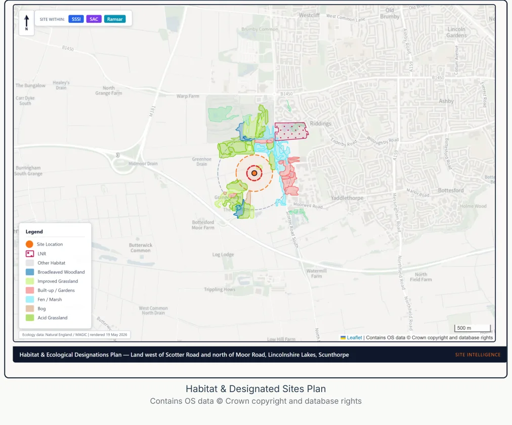
Many authoritative sources, one clear brief.
Each dataset adds a layer the others can read. Flood informs viability, heritage shapes design, ground risk sets cost. They resolve into a single source-traced read — not a stack of disconnected PDFs.
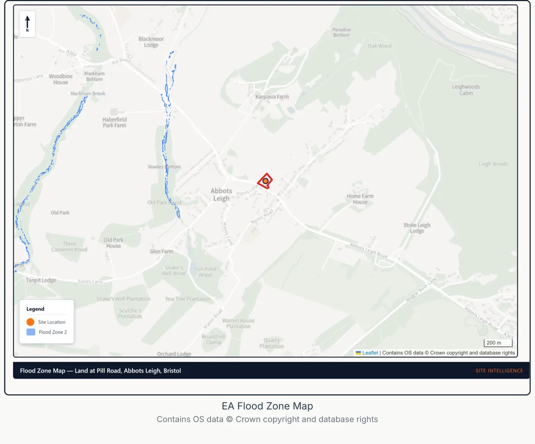
- Environment Agency — Flood zones 2 & 3, surface-water risk
- Historic England — Listed buildings, conservation areas
- Natural England — SSSIs, priority habitats, BNG baseline
- British Geological Survey — Geology, made ground, radon
- Coal Authority — Mining legacy, stability
- Ordnance Survey — Boundary, topography, base map
- Planning Data Platform — Designations, allocations, policy
- HM Land Registry — Title extent, ownership context
- Department for Transport — Highways, access, traffic counts
What lands on your desk
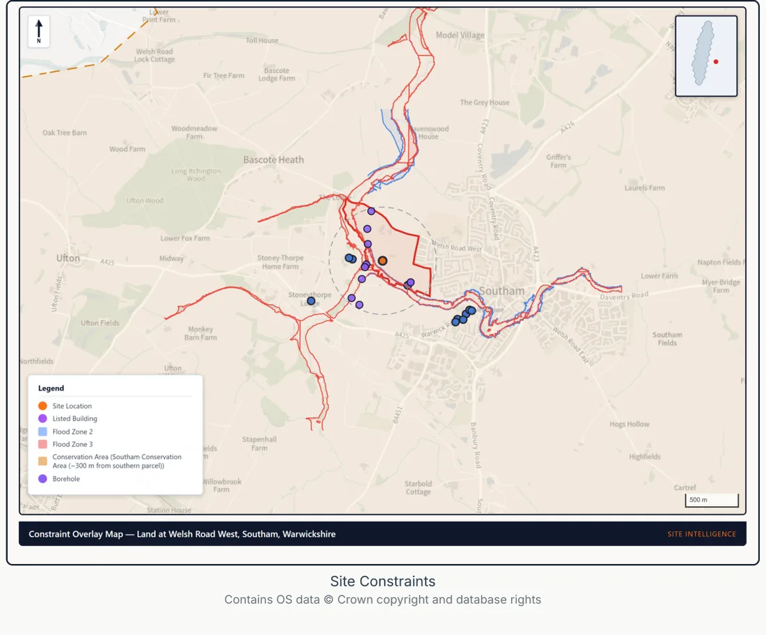
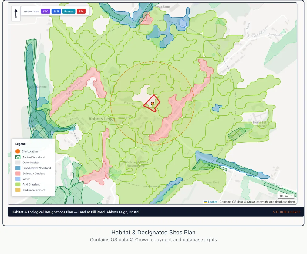
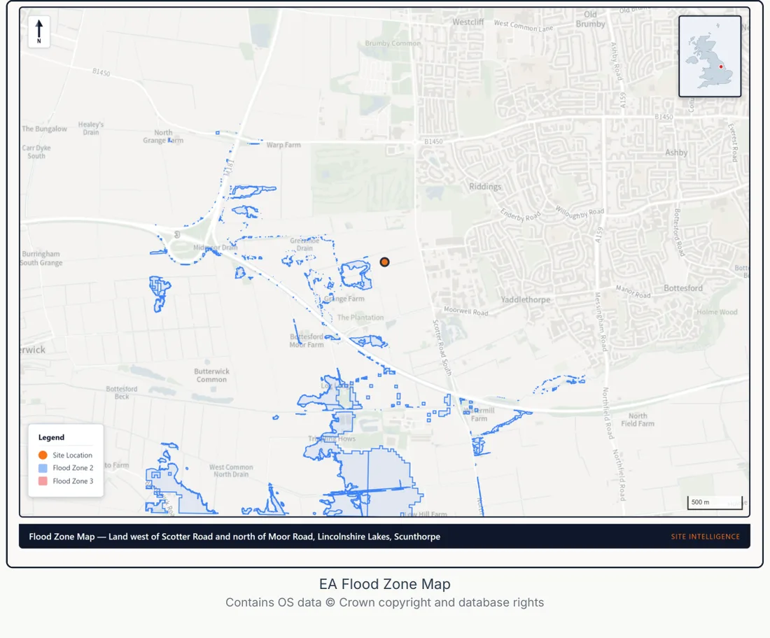
A source-traced desktop brief — the site, what constrains it, what is likely feasible, and exactly which specialists to instruct. Flip through the sections.
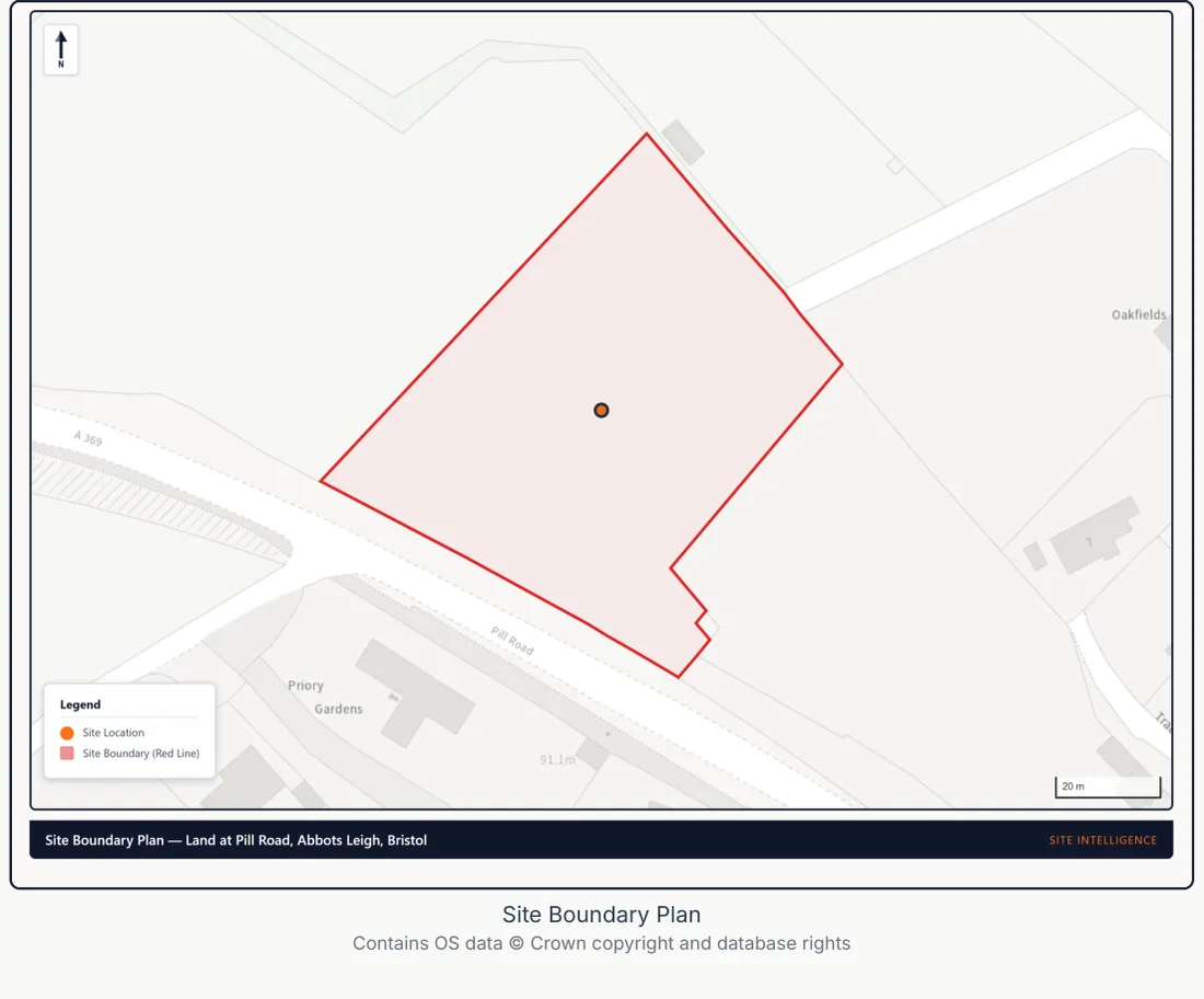
The site, established
We fix the boundary against Ordnance Survey mapping and HM Land Registry title extent, then establish the developable area, topography and access frontage before any constraint is read.
- Area
- ≈ 1.4 ha gross
- Frontage
- Adopted highway, north-west
- Base data
- OS · HM Land Registry
 PLOT · INDICATIVE© Esri, Maxar
Coming soon — see what fits on your site
Indicative site layouts, generated alongside your evidence brief, showing what could fit within your boundary before you spend anything on design.
One email when it launches. We will not use your address for anything else.
The traditional route vs PF & Co
Not a replacement for your consultant team — a faster, source-traced route to the point where you instruct them well. A Tier 1 desktop brief, quality-checked and issued in 48 hours.
Real reports. Real sources. No black box.
Four cumulative products, every report drawn from authoritative government data — British Geological Survey, Environment Agency, Historic England, Natural England, and 126 more. Every figure traced to source. Every report run through 200+ automated quality checks before issue. If a planning officer asks "where did you get this?", one click.
Why Site Intelligence™
Three ways a fast, accountable early brief de-risks the decision to proceed.
Speed
Assembling the early picture the traditional way means coordinating several separate firms over many weeks. We deliver one source-traced desktop brief in 48 hours, so every specialist you then instruct starts better informed. One order. One delivery.
Cost
Specialist desktop reports run £800–£5,000 each, and industry estimates suggest a large share of early-stage development projects are abandoned, often after significant sunk cost. A fixed-price brief from £199 shows which reports your site is likely to need before you commission any of them.
Integration
Early-stage evidence usually arrives as separate documents that never reference each other. Ours is one joined-up read — when flood mitigation adds £200k to your build costs, the viability picture already reflects it.
Every report references every other report. Flood risk feeds viability. Ecology shapes layout. Heritage constrains design. CIL affects finance. One integrated early brief, not a stack of disconnected PDFs.
Built to keep your project moving
You place the order; we assemble the evidence, run the checks, and issue a source-traced brief within 48 hours. Your team keeps moving, and when a decision warrants extra assurance, an expert sign-off is available as an add-on.
- 0hYou
You place the order
Address, development type and scale. No sign-up, no chasing.
- 0–24hSite Intelligence
We assemble the evidence
Around 130 authoritative datasets cross-referenced into one read of the site.
- 24–47hSite Intelligence
We run the quality checks
200+ automated checks on sources, figures and cross-references before anything goes out.
- 48hSite Intelligence
Brief issued
A source-traced desktop brief lands — built to the RICS standard on the responsible use of AI.
- On requestYou
You request an expert sign-off
For the decisions where you want a person to have read every page.
- Beyond 48hSite Intelligence
We carry out the sign-off
A named personal sign-off or a chartered-planner review. The reviewer reads the whole brief, which is why it adds time beyond the 48 hours.
Built to the RICS standard on the responsible use of AI before it became mandatory on 9 March 2026. Automation does the heavy lifting: every brief runs through 200+ automated quality checks before issue, and a named personal sign-off or chartered-planner review is available as an add-on when you want it.
Trusted data sources
We use the same authoritative datasets that planning officers rely on — government, regulated-industry and partnership sources.
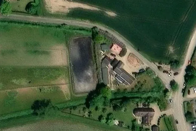
Mapped to your site, not a checklist
Every report turns the data into clear, site-specific maps and evidence. Real pages from a sample pack:
Ready to see what your site needs?
A source-traced desktop pack, quality-checked and on your desk within 48 hours. Fixed prices from £199.