Skip to content
Development decision intelligence · four cumulative products

Decide a site before you commit — planning reports for development sites

Before you spend a lot, spend a little to make a better decision. These are the planning reports that evidence whether a site is worth pursuing before you commit serious money — 55+ of them, selected automatically from your site's constraints. Tier 1 desktop study. You pick a product, we do the rest.

55+
Reports available
130
Data sources
48hr
Delivery

How counts work:We sell four cumulative products. The catalogue holds 55 distinct report types; the reports your site receives are a subset, triggered by its constraints. The figures above are maintained from a single internal register and audited periodically.

How the decision is evidenced
Decide at gate 1, bring in chartered specialists at gate 2. The reports are a Tier 1 desktop study, so most of them — Planning Statement, Site Appraisal, Housing Needs, Archaeological DBA, HRA Nutrient Neutrality, Affordable Housing, Sustainability & Energy, the strategic feasibility suite — are fully deliverable at desktop under industry standards (RTPI, CIfA, Defra calculators, PPG Standard Method). For workstreams where chartered-body standards (CIEEM, GLVIA3, BS 5837, BS 10175, GPA3) mandate site fieldwork — ecology walkovers, viewpoint photography, individual tree inspection, site reconnaissance, heritage setting visits — the report produces the scoping brief that lets a chartered specialist execute faster and cheaper, and complements that specialist rather than substituting for them.

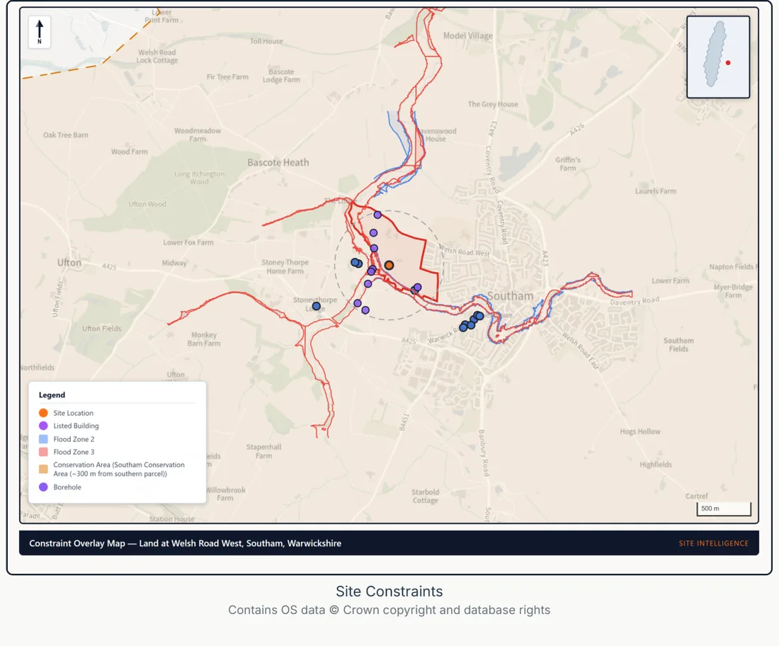
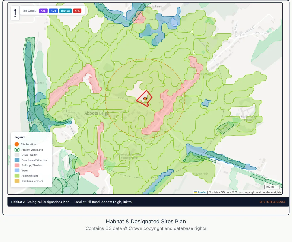
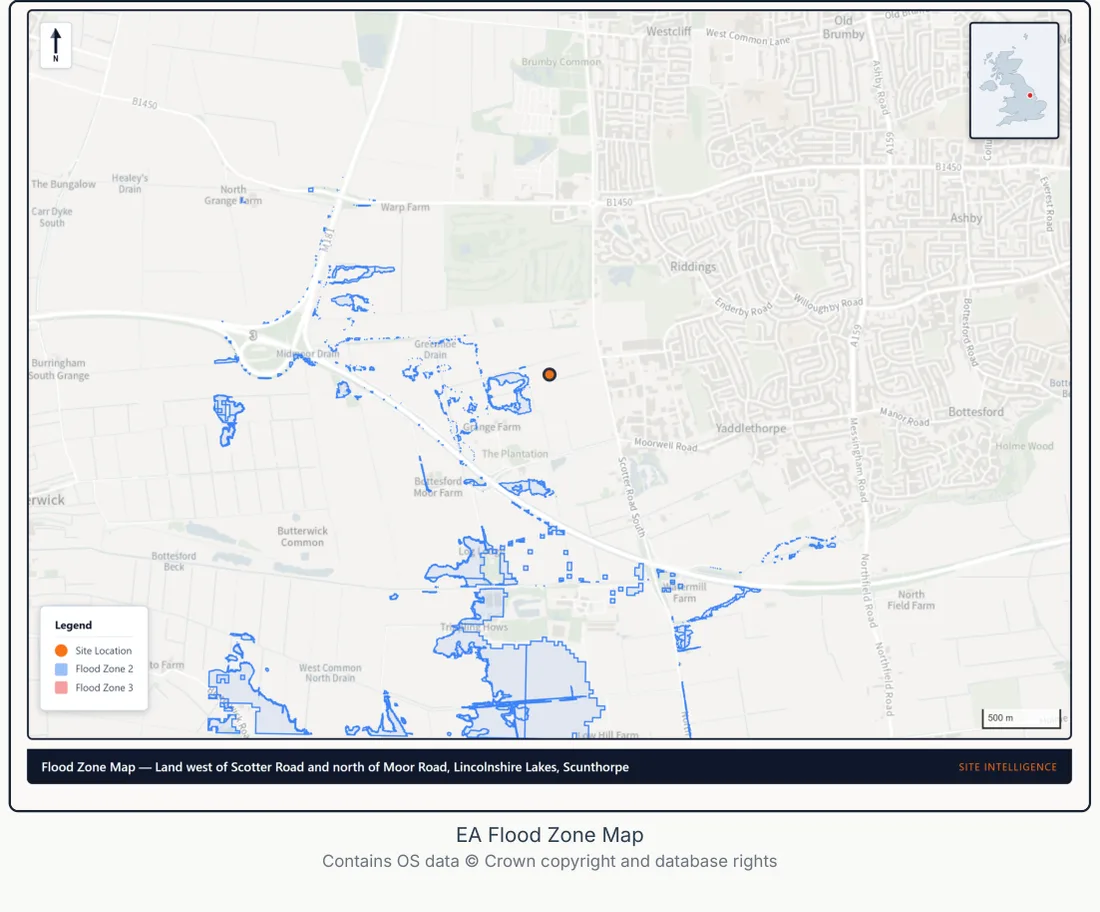
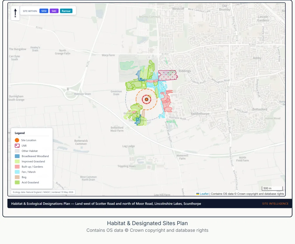
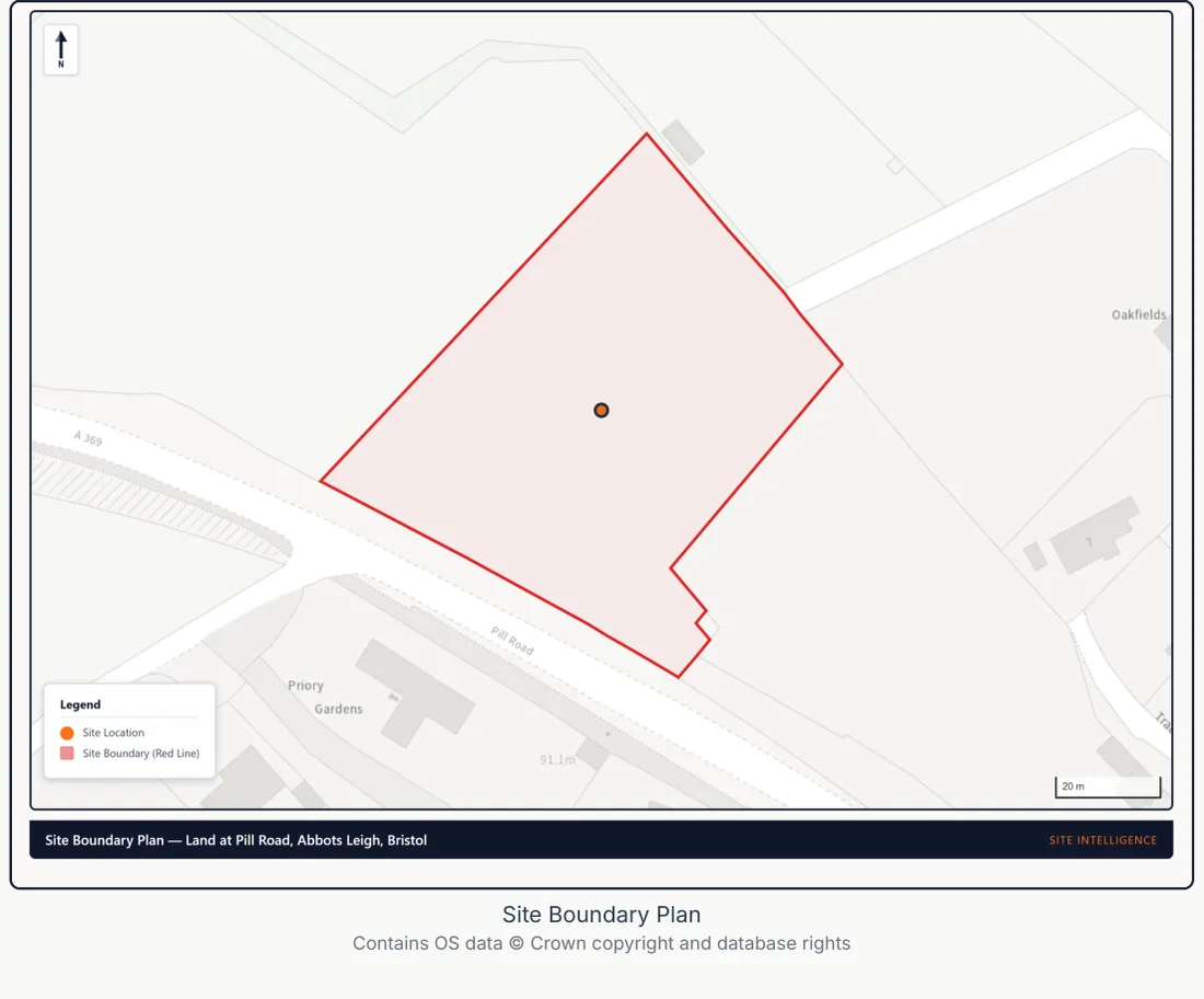
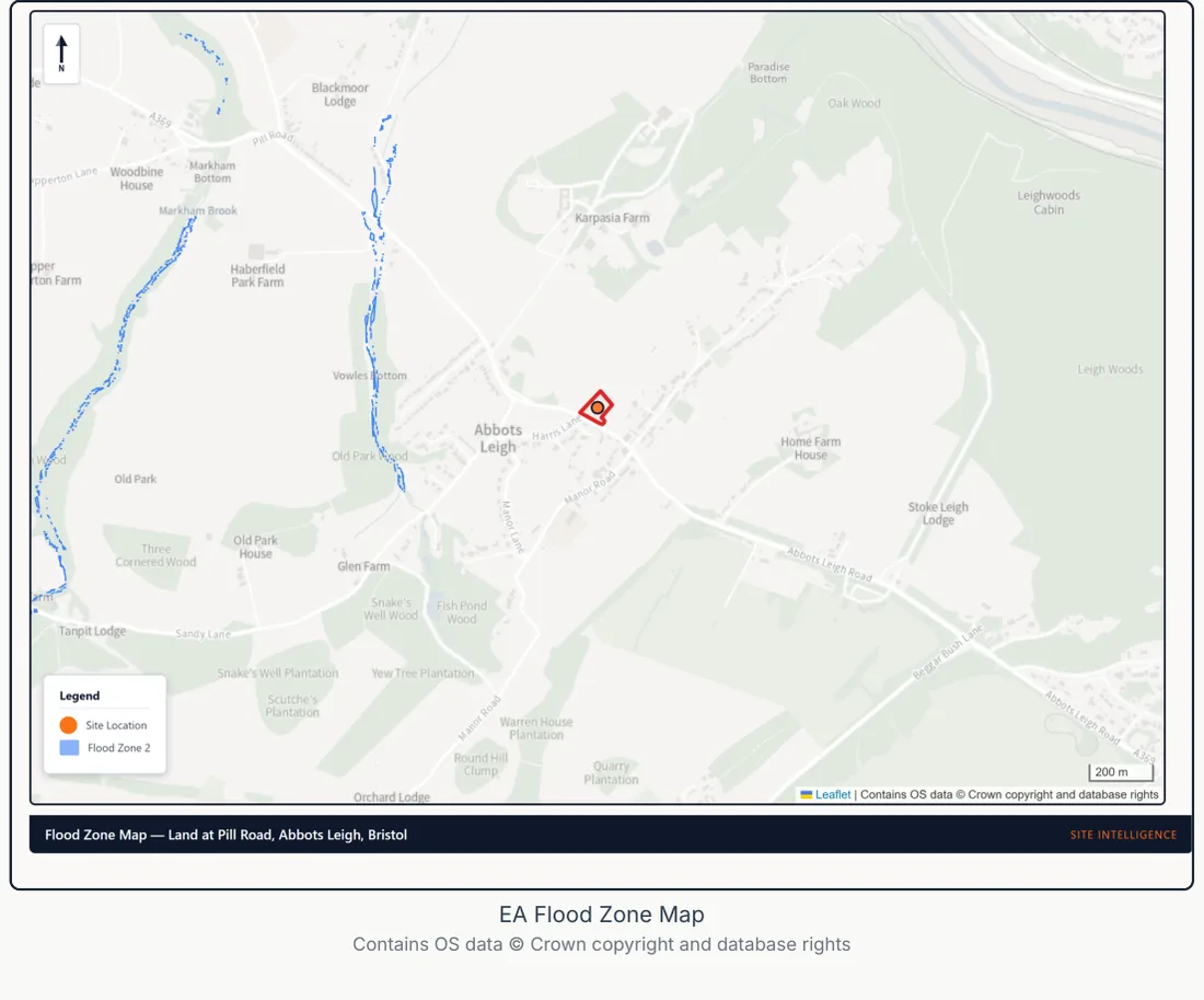
The data, mapped to your site

Behind every report: clear, site-specific maps and evidence. Sample pages:

Constraints overlay — sample Site Intelligence report page
Constraints overlay
Listed buildings, flood zones and the conservation area, mapped to the site.
Biodiversity & habitats — sample Site Intelligence report page
Biodiversity & habitats
Habitat parcels and ecological designations across the site.
Flood risk — sample Site Intelligence report page
Flood risk
Environment Agency flood zones across the site and its surroundings.
Habitat designations — sample Site Intelligence report page
Habitat designations
Priority habitats and designated sites mapped around the site.
Site boundary plan — sample Site Intelligence report page
Site boundary plan
The red-line boundary on Ordnance Survey mapping.
Site in its setting — sample Site Intelligence report page
Site in its setting
The site mapped in its wider context.
Pricing

Full pricing reference

Spend a little before you spend a lot. All four products on one page, priced by dwelling band, so you can match the spend to the decision you are making. Each product includes everything from the products above it, and all four are delivered in 48 hours.

Product1–9 units10–50 units51–200 units200+
1. Site Appraisal£199£299£399call
2. Feasibility Intelligence£895£1,795£2,495call
3. Pre-Application Pack£1,995£3,495£4,995call
4. Planning Intelligence PackPriced on enquiry

Optional extras

Scheme Optimiserincluded with Feasibility and aboveIncluded
Outline Planning Checkfor sites with outline consent · standalone, or +£395 with Product 2£695 fixedall bands

All four products: 48-hour turnaround. Schemes 200+ units: call 01483 363 020.

Product 1

Site Appraisal

£199 – £399

"Is this site worth looking at?" — A go/no-go verdict in 48 hours. 1 report. £199 for 1–9 dwellings, £299 for 10–50, £399 for 51–200; 200+ priced on enquiry.

Included

Site Appraisal
Go/no-go verdict with traffic-light constraint summary, fatal flaw check, and list of reports needed if you proceed
Product 2

Feasibility Intelligence

£895 – £2,495

"Should I commit capital to this site?" — Everything in Product 1, plus full feasibility analysis with BCIS costings and executive summaries. 12 reports.

Executive Summaries

5 reports tailored to different stakeholders

Developer Summary
Go/no-go verdict with key numbers, risk assessment, and recommendation for the developer or investor
Architect Summary
Design constraints digest — setbacks, heights, materials, heritage sensitivity, and ecology buffers
Technical Summary
Ground conditions, flood risk, ecology, infrastructure, and contamination digest for the engineering team
Risk Summary Sheet
All identified risks RAG-rated in one place with mitigation actions and programme impact
Client Decision Pack
Plain English explainer of the entire project — process, sequencing, responsibilities, and terminology for non-technical stakeholders

Strategic Reports

6 reports covering market, finance, and planning strategy

Concept Feasibility Report
2–4 design options with cost comparison, planning route per option, and budget architecture analysis
Market Intelligence Report
Comparable sales, GDV estimates, rental yields, and Development Opportunity Score based on Land Registry and market data
Development Strategy Report
Planning route analysis — permitted development vs householder vs full application vs lawful development certificate
Planning Strategy Advisory Report
Policy analysis, heritage strategy, enforcement risk assessment, appeal risk scoring, and pre-application strategy
Site Acquisition Intelligence Report
Development capacity, GDV, build cost, residual land value, and go/no-go recommendation for land purchase decisions
Development Finance Summary
Investment memo — GDV, build cost, profit on cost, residual land value, sensitivity analysis, and lender-ready dashboard
Product 3

Pre-Application Pack

£1,995 – £4,995

"Engage the council from a position of strength" — Everything in Products 1 and 2, plus 35+ maps, all constraint-triggered technical reports, and planning documents. Up to 44 reports.

Planning Documents

6 reports — always included with Product 3

Planning Statement
Submission-ready policy evidence and planning justification referencing NPPF and local plan policy
Design and Access Statement
DMPO 2015 Article 9 compliant statement covering five statutory design aspects and access analysis
Pre-Application Advice Report
Submission-ready pre-app pack with 5–10 targeted questions for the LPA based on your site's specific constraints
Construction Management Plan
Site logistics, delivery routes, noise and dust mitigation, working hours, and neighbour management strategy
Phasing and Delivery Plan
Programme, phasing strategy, delivery milestones, and construction sequencing
Condition Discharge Strategy
Anticipated planning conditions with discharge approach, timelines, and responsible parties

Constraint-Triggered Technical Reports

Up to 24 reports — generated only when your site's constraints require them

Flood Risk Assessment
Sequential test, exception test, climate change allowances, SuDS strategy, and insurance/mortgage section
Flood Zone 2/3 or site over 1 hectare
Heritage Statement
Significance assessment, impact on setting, and Historic England GPA3 methodology
Listed building, conservation area, or heritage setting
Transport Statement
Trip generation, access analysis, parking provision, PTAL scoring, and sustainable travel assessment
Development generating significant traffic
BNG Screening Statement
Biodiversity net gain baseline, statutory exemption checks, habitat mapping, and GCN risk zones
Most applications post-February 2024
Geotechnical Desk Study
BGS geology, borehole records, groundwater, shrink-swell clay, radon, and foundation recommendations
Significant ground risk identified
Phase 1 Contaminated Land Desk Study
LCRM 2020 / BS 10175 preliminary risk assessment with conceptual site model and remediation screening
Historic industrial/military land use or contamination indicators
CIL Liability Assessment
Community Infrastructure Levy calculation, exemption eligibility, relief checks, and pre-populated CIL forms
Site in a CIL-charging authority
Preliminary Ecological Appraisal
Desktop ecology screening — designated sites, priority habitats, protected species indicators, and habitat mapping
SSSI, SAC, SPA, priority habitat, or protected species nearby
Noise Impact Assessment
BS 4142 / BS 8233 / ProPG noise screening for residential schemes near roads, railways, or commercial uses
Near road, rail, or commercial noise source
Air Quality Assessment
IAQM/EPUK screening with AQMA proximity analysis, construction dust risk, and mitigation strategy
Near Air Quality Management Area
Arboricultural Impact Assessment
Desktop arboricultural assessment — TPO register, LiDAR canopy analysis, BS 5837 categorisation, and RPA mapping
TPOs, significant trees, or ancient woodland
Landscape and Visual Impact Assessment
Landscape character assessment, visual receptors, and policy compliance for sensitive landscapes
AONB, National Landscape, Green Belt, or sensitive setting
Archaeological Desk-Based Assessment
HER data, archaeological potential, historic mapping analysis, and mitigation recommendations
Archaeological Priority Area or known archaeological sites
Housing Needs Assessment
Local housing demand, affordability analysis, demographics, and recommended housing mix
10+ dwellings
Daylight and Sunlight Assessment
BRE 209 methodology — VSC, APSH, NSL, and sun-on-ground analysis for impact on neighbouring properties
Dense urban site or proximity to existing dwellings
Socio-Economic and Social Value Assessment
Employment impact, community services, education capacity, and social value quantification
10+ dwellings or major development
Townscape and Visual Impact Assessment
Urban character assessment, visual amenity analysis, and design response in sensitive townscapes
Conservation area or urban sensitivity
Open Space Strategy
Open space requirements, play space provision, and green infrastructure strategy
Major residential development
Parking Survey
Evidence-based parking demand calculation and provision analysis against local standards
Parking provision contentious or constrained
Retail Sequential Assessment
Sequential test for retail and commercial uses outside designated town centres
Retail/commercial use outside town centre
Wind Microclimate Screening
Wind comfort and safety screening for tall buildings or exposed sites
Tall buildings or exposed sites
HRA Nutrient Neutrality Assessment
Nutrient budget calculation and mitigation strategy for affected SAC catchments
Site in nutrient neutrality catchment
Biodiversity Gain Plan
Full biodiversity gain plan with habitat creation, enhancement, and management strategy
Major development requiring full BNG plan
BNG Monitoring Report
Post-consent biodiversity monitoring framework and reporting schedule
Major development with BNG obligations
35+ maps and overlays are also generated from enrichment data — site location, constraint overlay, heritage, flood zones, ecology, accessibility, site boundary, comparable sales, planning history, borehole locations, infrastructure, CIL zones, habitat plan, and development envelope.
Product 4

Planning Intelligence Pack

Quote only

"Everything for submission, except the drawings" — Everything in Products 1, 2, and 3, plus a full application pack drafted to submission standard. 13 additional reports.

Submission Documents

13 reports for full planning application submission

Sustainability and Energy Statement
Part L compliance, SAP analysis, MEES, carbon reduction strategy, and renewable energy feasibility
EIA Screening Opinion
Schedule 2 screening assessment for Environmental Impact Assessment requirements
Affordable Housing Statement
Affordable housing policy compliance, tenure mix, and viability negotiation
Infrastructure and Drainage Strategy
SuDS hierarchy, foul and surface water drainage, and utilities capacity assessment
Framework Travel Plan
Sustainable travel measures, modal shift targets, and monitoring framework
Statement of Community Involvement
Public engagement strategy, consultation outcomes, and response to feedback
Site Development Parameters
Built form parameters, density ranges, and development envelope for outline applications
Pre-Construction Design Review
95-check design coordination review for construction readiness
Application Covering Letter
Formal covering letter to the LPA for planning application submission
Application Summary
Executive summary of the planning application for officer reference
Submission Pack Index
Full index of all submitted documents with cross-references
Validation Checklist
LPA validation requirements cross-check to ensure the application is valid on submission
Next Steps and Recommendations
Post-submission action plan, timeline, and recommended follow-up
Scope clarity

The pack is drafted to LPA submission standard. Some applications will still require site visits, specialist measured surveys, intrusive ground or ecology investigations, architect drawings, formal consultant sign-off, or LPA-specific validation documents. Where these triggers apply to your site, they are flagged in the pack so nothing is left ambiguous at validation.

Included as standard

Scheme Optimiser

Included with Feasibility and above

"What should you build?" — Included as standard with Feasibility Intelligence and Pre-Application Pack. Up to 5 ranked development strategies with full viability appraisals.

Included
1–9 dwellings
Included
10–50 dwellings
Included
51–200 dwellings
Up to 5 ranked development strategies
Dwelling count range (low / medium / high)
Housing mix by bedroom count
GDV, build costs, CIL, developer profit
Residual land value and maximum land price
Affordable housing and viability scenarios
Consent cost estimate and programme timeline
Policy compliance per strategy
Optional add-on

Outline Planning Check

£695 standalone · +£395 with Product 2

"Should I buy this site with outline consent — and what's the gap to full planning?" Fixed price across all dwelling bands, because the work scales with the conditions list, not the scheme size.

£695
Standalone
Order on its own when you're evaluating a site at acquisition stage.
+£395
As Product 2 add-on
Tick the box during checkout when you're already ordering Feasibility Intelligence.
Conditions discharge analysis — what needs clearing before you can break ground
Reserved matters strategy — appearance, layout, scale, landscaping, access
Roadmap from outline consent to full planning permission
Indicative cost projection for the gap (specialist reports, design, fees)
Highlights any constraints introduced or worsened since outline grant
Recommendations on which Site Intelligence products you would need next
Who buys this: developers, land buyers, and self-builders evaluating a site that already has outline planning granted. The report tells you whether the consent is worth acquiring and what it will take to get to full permission.
Coverage

Which product includes which report?

Every product includes everything from the products below it. Tick = included.

ReportP1P2P3P4
Site Appraisal
Developer Summary
Architect Summary
Technical Summary
Risk Summary Sheet
Client Decision Pack
Concept Feasibility Report
Market Intelligence Report
Development Strategy Report
Planning Strategy Advisory Report
Site Acquisition Intelligence Report
Development Finance Summary
Planning Statement
Design and Access Statement
Pre-Application Advice Report
Construction Management Plan
Phasing and Delivery Plan
Condition Discharge Strategy
Flood Risk AssessmentFlood Zone 2/3 or site over 1 hectare
Heritage StatementListed building, conservation area, or heritage setting
Transport StatementDevelopment generating significant traffic
BNG Screening StatementMost applications post-February 2024
Geotechnical Desk StudySignificant ground risk identified
Phase 1 Contaminated Land Desk StudyHistoric industrial/military land use or contamination indicators
CIL Liability AssessmentSite in a CIL-charging authority
Preliminary Ecological AppraisalSSSI, SAC, SPA, priority habitat, or protected species nearby
Noise Impact AssessmentNear road, rail, or commercial noise source
Air Quality AssessmentNear Air Quality Management Area
Arboricultural Impact AssessmentTPOs, significant trees, or ancient woodland
Landscape and Visual Impact AssessmentAONB, National Landscape, Green Belt, or sensitive setting
Archaeological Desk-Based AssessmentArchaeological Priority Area or known archaeological sites
Housing Needs Assessment10+ dwellings
Daylight and Sunlight AssessmentDense urban site or proximity to existing dwellings
Socio-Economic and Social Value Assessment10+ dwellings or major development
Townscape and Visual Impact AssessmentConservation area or urban sensitivity
Open Space StrategyMajor residential development
Parking SurveyParking provision contentious or constrained
Retail Sequential AssessmentRetail/commercial use outside town centre
Wind Microclimate ScreeningTall buildings or exposed sites
HRA Nutrient Neutrality AssessmentSite in nutrient neutrality catchment
Biodiversity Gain PlanMajor development requiring full BNG plan
BNG Monitoring ReportMajor development with BNG obligations
Sustainability and Energy Statement
EIA Screening Opinion
Affordable Housing Statement
Infrastructure and Drainage Strategy
Framework Travel Plan
Statement of Community Involvement
Site Development Parameters
Pre-Construction Design Review
Application Covering Letter
Application Summary
Submission Pack Index
Validation Checklist
Next Steps and Recommendations
Provenance

130 authoritative datasets

Government, regulated-industry and partnership sources. Every data point traced to its original publisher.

Environment Agency

Flood zones, surface water, historic flooding, reservoir risk

British Geological Survey

Geology, ground conditions, boreholes, shrink-swell

Historic England

Listed buildings, conservation areas, scheduled monuments

Natural England

SSSI, SAC, SPA, Ramsar, priority habitats, ancient woodland

DEFRA

Air quality, agricultural land classification, MAGIC

Ordnance Survey

Mapping, boundaries, land use, topography

ONS

Census demographics, housing data, affordability ratios

DfT

Traffic counts, road data, accident records

HM Land Registry

Comparable sales, ownership data, price paid

PHE / UKHSA

Radon data, contaminated land indicators

NBN Atlas

Protected species records (CC-BY licensed)

Cranfield / LandIS

Soil type, drainage, Soilscapes data

Scope honesty

What Site Intelligence doesn't cover

These are the things that either need boots on the ground, chartered sign-off, legal drafting, or that we explicitly choose not to offer. Our desktop reports tell you which of these you'll need before submission.

Specialist surveys (need boots on site)

  • BS 5837:2012 tree survey and arboricultural impact assessment
  • Phase 2 intrusive ground investigation (boreholes, trial pits)
  • Protected-species surveys — bat, great crested newt, reptile, badger
  • Full GLVIA3 landscape and visual impact assessment with photomontages
  • BRE 209 daylight / sunlight field modelling
  • BS 4142 noise measurement surveys
  • Continuous air-quality monitoring
  • Topographic and measured building surveys

Chartered / regulated submissions

  • RICS-compliant formal viability assessments (FVAs)
  • Architectural drawings and planning drawings
  • Structural engineering calculations and certification
  • Building Regulations applications (Parts A–S)
  • SAP / SBEM energy compliance (Part L)
  • Party wall awards under the Party Wall Act 1996
  • Section 104 drainage adoption agreements
  • DNO formal connection offers and grid adoption

Legal instruments

  • Section 106 agreement drafting and negotiation
  • Section 38 / 278 highway agreements
  • Unilateral undertakings
  • Legal opinions on land title or covenants
  • Appeal representation at hearings or inquiries

We choose not to cover

  • Fire safety reports / fire risk assessments — liability sits with a competent fire engineer
  • Enforcement matters and retrospective regularisation
  • CPO / compulsory purchase and land-acquisition advice
  • Construction-phase CDM monitoring
  • Commercial / contract drafting for appointments

Every Site Intelligence report flags exactly which of these follow-on surveys, chartered submissions, or legal instruments your scheme will need — so you buy the right specialists at the right stage, and don't waste money on things a desktop study can't replace.

Questions

Frequently asked questions

What is a desktop planning report?
A desktop planning report helps you decide whether a site is worth pursuing before you commit serious money. It is a professional Tier 1 desktop study prepared using authoritative datasets — government and regulated-industry sources including the Environment Agency, British Geological Survey, Historic England, Natural England, and more — without requiring a site visit. Desktop reports cover planning constraints, flood risk, ground conditions, heritage, ecology, transport, and contamination, and they are used for feasibility, pre-application engagement, and planning submissions.
How many reports do I get?
Up to 55+ reports depending on your product and site constraints. Product 1 (Site Appraisal) includes 1 report. Product 2 (Feasibility Intelligence) includes 13 reports. Product 3 (Pre-Application Pack) includes everything in Products 1 and 2 plus up to 30 constraint-triggered technical reports, 35+ maps, and 6 planning documents. Product 4 adds a further 13 submission documents.
Do I need a flood risk assessment for my planning application?
You need a Flood Risk Assessment if your site is in Flood Zone 2 or 3, or if it is over 1 hectare in Flood Zone 1. Our system automatically checks Environment Agency flood maps and triggers a desktop FRA when required. This is included in Product 3 (Pre-Application Pack) and above.
What reports does my local authority require?
Requirements vary by LPA and by your site's constraints. Our system analyses 130 authoritative datasets to determine which reports your site triggers — flood risk, heritage, ecology, transport, contamination, noise, air quality, and more. Product 3 generates every constraint-triggered report your LPA is likely to require.
How long do the reports take?
All products are delivered within 48 hours. This includes Site Appraisal, Feasibility Intelligence, and Pre-Application Packs. Planning Intelligence Packs (Product 4) are scoped and quoted individually. As standard, every brief is assembled from 130 authoritative datasets and passes 200+ automated quality checks before issue. For clients who want extra assurance, an optional add-on provides a named personal sign-off or a chartered-planner review; because the reviewer reads the whole pack, it adds time beyond the 48 hours.
What is the difference between Site Appraisal and Feasibility Intelligence?
Site Appraisal (from £199 for 1–9 dwellings, £299 for 10–50, £399 for 51–200) gives you a go/no-go verdict with a constraint summary and fatal flaw check. Feasibility Intelligence (from £895) adds a full feasibility report, BCIS-informed development costings, market intelligence, and five executive summaries tailored to different stakeholders (developer, architect, technical team, risk, and client). Feasibility Intelligence is for serious decision-making; Site Appraisal is for quick initial checks.
What is a constraint-triggered report?
A constraint-triggered report is generated only when your site's data requires it, so you only pay to evidence the risks that actually bear on your decision. For example, a Heritage Statement is triggered when the site is near a listed building or in a conservation area. A Flood Risk Assessment is triggered when the site is in Flood Zone 2 or 3. You don't choose individual reports — the system detects what's needed and generates them automatically.
What is the Scheme Optimiser?
The Scheme Optimiser is included as standard with Feasibility Intelligence (Product 2) and Pre-Application Pack (Product 3). It analyses your site and produces up to 5 ranked development strategies with dwelling counts, viability appraisals, land values, and consent programmes — at no extra cost.

Ready to order?

Enter your site address, choose your product, and pay securely online. Your brief arrives within 48 hours, run through 200+ automated quality checks as standard.

Want extra assurance? A named personal sign-off or a chartered-planner review is available as an optional add-on — it adds time beyond the 48 hours.