Skip to content
Choosing how to assess a site

Two ways to read a site.

A data platform shows you what is on the land. We turn it into a reasoned view of what it means, with the evidence behind it. Flip the switch.

Same site. Two very different outputs. See the free example
The platform view
Here is what is on the land
Raw data · you do the rest
PA
Planning applications & constraints
Mapped, daily-updated, nationwide
OW
Ownership & title
Who owns it, freehold or lease
£
Comparables & price paid
Sold values and listings on demand
AL
Allocations & local policy
Draft and adopted, clickable
FB
Flood, BNG & green belt
Environmental layers overlaid
AI
An instant automated summary
Assembled by the machine in seconds
Which leaves you with
The analysis, the design and the judgement still to do.
Where software stops

The five rungs from data to decision.

Everyone starts with the same data. A platform climbs two rungs brilliantly. The decision lives on the three above the line, and that is a judgement, not a query.

Constraints, ownership, comparables, allocations, flood and policy layers. The starting material everyone works from.
A platform serves this well. So do we. It is the floor, not the product.
Daily application alerts, mapping any parcel in the country, finding new opportunities at scale. Genuinely useful, and honestly not what we do.
If your job is to monitor a pipeline and source sites yourself, a platform earns its keep.
Automation ceilingjudgement begins
Planning, feasibility, viability and constraints, each worked by the relevant specialism: heritage, landscape, policy, flood, economics. Reasoned positions, not a layer read-out.
A machine can list the heritage asset. It cannot tell you whether harm is justified by public benefit.
An illustrative scheme that answers the constraints: yield, layout, access and how the site sits in its setting and its slope. The difference between knowing the limits and showing a way through them.
Constraints mapped is a question. A scheme is the start of an answer.
Every position grounded in the appeal record and current policy, cited by paragraph, and checked by a person who puts their name to it. The part a committee, an investor or an inspector actually tests.
This is what a download cannot give you, and what the decision rests on.
Line by line

A fair tick-list.

We share the top of the list now. Our free check is instant and self-serve too, so a platform no longer owns that ground. It stays ahead on live tracking and breadth. We pull ahead on everything that turns data into a decision.

Capability
Data platform
Site intelligence
Constraints identified for a site
A free, instant check you run yourself
Self-serve, no sign-up
Live daily planning-application alerts
Site sourcing at scale
Ownership & comparables as live layers
½
Maintained policy & allocation layers, nationwide
Planning judgement worked by discipline
An illustrative scheme drawn for the site
Viability appraised, not just summarised
Policy cited by paragraph, verified not recalled
Reasoning grounded in the appeal record
Adversarial QA, then a named human check
Does this well½ In part Not its job

No column wins every row, and the instant read is now free on both sides. We add the rows that decide whether a scheme is worth pursuing.

In fairness

What a data platform does better.

We would rather be straight about this than oversell. For a real set of jobs, a platform is the right tool, and these are them.

Breadth of data

Maintained layers across the whole country: ownership, comparables, allocations, policy, energy. We go deep on one site; they go wide across all of them.

Live and always-on

Daily alerts and real-time tracking you can dip into any day. We are commissioned per site, and our free check is a snapshot, not a monitor.

Sourcing at scale

Finding new opportunities anywhere in Britain. Our free check reads a site you already have in mind; it does not go hunting for them.

The two sit in the same stack, not in a ring. Use a platform to find and filter, run our free check for an instant read, and commission us when the answer has to hold at offer, at committee, or at appeal.
A free example

If you use our free check, you get this.

Not just numbers on a screen. A branded snapshot you can save, print and forward, the moment you run a check.
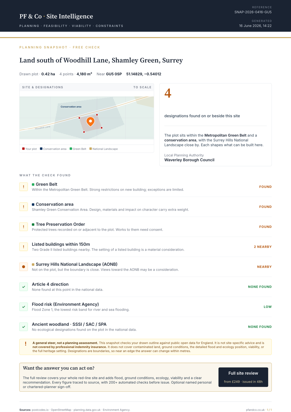
  • An instant read on your exact site
    Drop a pin or draw your plot. We check the outline, not just a postcode.
  • The designations that shape it
    Green Belt, conservation area, flood zone, listed buildings, TPOs, National Landscape and more.
  • Your authority and a constraint map
    The local planning authority, with the boundaries drawn over your plot.
  • A branded PDF you can share
    Save it, print it, or forward it to your architect or partner.
  • A clear next step
    If you want the relied-upon answer, the full review picks up where this leaves off.
Free, instant, no sign-up

A general steer, not a planning assessment, and not covered by professional indemnity insurance.

Sample snapshotSample planning snapshot PDFFreeexample PDF
The short version

A platform tells you what is there.

We tell you what it means, where the risk sits, and back every word with evidence.