Short answer
Before you offer on a site, before you commission architects, and before you submit, you need to know whether historic land use could trigger Phase 2 intrusive investigation, a remediation bill, or an LPA contamination condition that holds up validation. A contaminated land desktop study tells you that, in writing, in 48 hours, from £199.
Technically, this is a Phase 1 Preliminary Risk Assessment: a planning-grade screen of historic land use, regulatory records, mining and landfill databases, BGS geology and radon mapping, used to establish whether a credible source-pathway-receptor pollutant linkage exists. It is the trigger document for whether Phase 2 ground investigation is required, and it is what most LPA validation officers expect to see on previously developed land.
PF & Co produces the desktop contaminated land layer within Site Appraisal (£199 to £399), with the full study built into the Pre-Application Pack (from £1,995).
Order a Site Appraisal or see a sample report.
When a small developer should order one
For a 1 to 20 unit residential or infill scheme, the contaminated land desktop study earns its keep at three moments:
- Before you bid or sign an option. You need the abnormal cost provision (Phase 2, remediation, gas protection) in the residual land value, not three months after exchange.
- Before you commission architects. Layout, basement, garden coverage and SUDS placement all shift if there is made ground or a contamination hotspot. Better to know before paying for design.
- Before you submit. Many LPAs request a Phase 1 desk study at validation on previously developed land. Validation requirements vary by LPA, site history and application type, but on brownfield sites the request is routine.
Typical small-developer triggers we see weekly:
- Garage court redevelopment, where historic vehicle maintenance and fuel storage are likely.
- Former workshop, joinery or light industrial unit being converted or replaced.
- Infill plot behind a parade of shops, with historic dry cleaner or petrol station nearby.
- Made ground or imported fill of unknown origin on a sloping or levelled plot.
- Former orchard, nursery or smallholding with historic agricultural chemical use.
- Site within a radon affected area per the UK Radon Atlas.
- Site identified on the LPA Part 2A contaminated land register, or adjacent to historic landfill.
NPPF paragraphs 196 to 197 place responsibility on developers and landowners to ensure land is suitable for its proposed use, and Part 2A of the Environmental Protection Act 1990 sits behind that.
This page covers the desktop, or Phase 1, layer. For the wider geo-environmental framework, see our Phase 1 geo-environmental desk study. Both refer to the desk-based Preliminary Risk Assessment per the GOV.UK Land Contamination Risk Management framework.
What our contaminated land desktop study covers
| In the desktop study | Sourced from |
|---|---|
| Historic OS map regression (1880s onwards) | Historic Ordnance Survey maps |
| Part 2A contaminated land register | LPA register where published |
| EA permit and pollution incidents register | EA public register |
| Historic landfill database | EA and supporting datasets |
| Mining legacy (coal, non-coal, brine, gypsum) | Coal Authority and BGS records |
| Radon affected area screening | UK Radon Atlas (UKHSA / BGS) |
| BGS geology and made ground | BGS GeoIndex |
| Asbestos likelihood from historic building age and use | Building age and sector-specific profiles |
| Fuel storage and dry cleaning history | Sector-specific historic datasets |
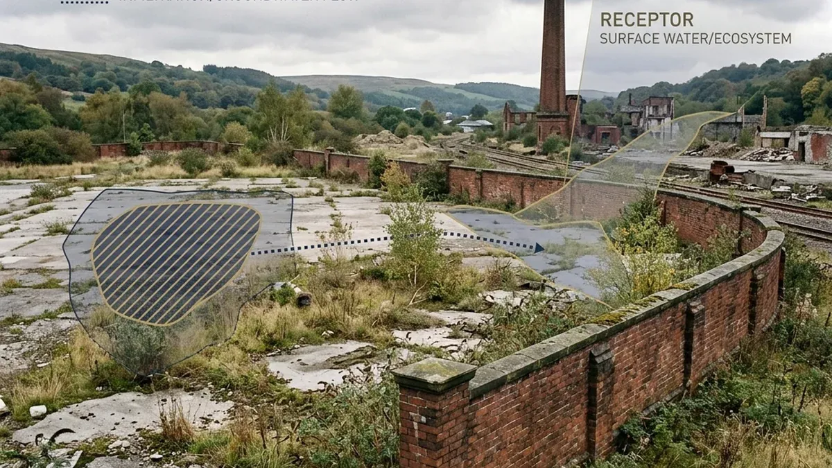
| Receptor identification | Site geometry, groundwater vulnerability, nearest controlled waters |
| Source-pathway-receptor linkage assessment | Combined dataset judgment per LCRM framework |
National datasets are authoritative as far as they go, but some contamination records are local, private or incomplete. The report flags where dataset coverage is partial and what that means for the residual risk.
What you receive in the report:
- A constraints map with the red-line boundary and contamination indicators.
- A historical land use summary from OS map regression.
- A source-pathway-receptor table tied to the proposed use.
- An LPA validation note for the contamination condition.
- A Phase 2 trigger recommendation: yes, no, or conditional on layout.
- An indicative abnormal cost allowance for the bid model or appraisal.
Where the desktop flags a credible pollutant linkage, the report names an indicative Phase 2 ground investigation scope (rotary bore, trial pits, laboratory analytical schedule for relevant contaminants), an indicative cost range of £8,000 to £20,000, and a typical 4 to 8 week timeline. The scope is indicative for budgeting and programme. A chartered geo-environmental engineer designs the final intrusive investigation.
What the desktop study does not replace
The desktop layer is a planning-grade screening, not a substitute for specialist work. It does not include, and does not replace:
- Phase 2 intrusive ground investigation, soil and groundwater sampling, or BRE 365 infiltration testing.
- Ground gas and vapour monitoring, or a BS 8485:2015 + A1:2019 ground gas risk assessment.
- A CL:AIRE Definition of Waste Code of Practice site-specific assessment.
- A remediation strategy, method statement or verification report.
- A chartered geo-environmental engineer's signed Phase 1 under PI, where formal lender, funder or vendor reliance is required.
- Foundation engineering recommendations.
Where any of these are triggered, the report names the specialist study, indicative cost range and typical timeline, so the project programme and budget can absorb it cleanly. If your funder or vendor needs reliance, commission a chartered Phase 1 from a geo-environmental consultancy. Our desktop study gets you to the bid and the pre-app with eyes open.
When £199 is enough, and when it is not
| Pack | What it does for contaminated land | Decision moment | Price |
|---|---|---|---|
| Site Appraisal | Historic land use, contamination indicators, Phase 2 trigger | Before you bid | From £199, 48 hours |
| Feasibility Intelligence | Adds Phase 2 and remediation abnormal cost provision | Pre-acquisition, pre-architect | From £895, 48 hours |
| Pre-Application Pack | Full desktop contaminated land evidence section ready for pre-app | Pre-app meeting booked | From £1,995, 48 hours |
| Planning Intelligence Pack | Submission-ready, alongside Phase 2 and remediation strategy where commissioned | Application submission | Tailored, 48 hours |
£199 is enough when you are screening before offer, deciding whether to proceed past heads of terms, or protecting architect fees on a small infill plot.
£1,995 is the right level when you have a pre-app booked, the LPA will read the contamination evidence, and you need the source-pathway-receptor judgment, validation note and abnormal cost provision in one document.
Equivalent consultancy Phase 1 desk studies are typically quoted at £600 to £1,500 over 2 to 4 weeks. We deliver the desktop layer in 48 hours because the dataset analysis is systematised and the judgment is written by planners who know how an LPA validation officer reads it. For complex sites or reliance, a chartered geo-environmental Phase 1 remains the right instruction.
For the wider planning report context, see our guide to what reports you need for planning permission.
Send the boundary today
Send postcode, red-line boundary, intended use and indicative dwelling count. Receive the constraint screen, historic land use, source-pathway-receptor judgment and Phase 2 cost provision in 48 hours.
For wider planning context, see the GOV.UK planning permission guidance.
- Screening before bid or option: Order a Site Appraisal from £199.
- Reviewing scope before purchase: See a sample report.
- Preparing for pre-app or submission: Phase 1 desk study within the Pre-Application Pack from £1,995.