Planning & Regulation Mar 16, 2026 5 min read
Grey Belt Explained: What Landowners and Developers Need to Know in 2026
Grey belt is the most significant change to Green Belt policy in decades. If you own or are looking to develop land within the Green Belt, this policy shift could unlock sites that were previously untouchable. Here is what it means and what to do about it.
Grey belt is the most talked-about concept in English planning right now. Introduced in the revised National Planning Policy Framework published in December 2024, it creates a new category of land within the Green Belt that is, for the first time, explicitly identified as suitable for development. If you own land in the Green Belt, or you are looking to acquire it, this is the single most important policy change you need to understand.
What Qualifies as Grey Belt Land
The term "grey belt" is defined at paragraph 142 of the NPPF. It covers land within the Green Belt that has been "previously developed" or that "does not strongly contribute" to any of the five purposes of Green Belt set out at paragraph 143. Those five purposes are: checking the unrestricted sprawl of large built-up areas; preventing neighbouring towns from merging into one another; assisting in safeguarding the countryside from encroachment; preserving the setting and special character of historic towns; and assisting in urban regeneration by encouraging the recycling of derelict and other urban land. If your land fails to serve any of these purposes strongly, it may qualify as grey belt — regardless of what colour it appears on the Local Plan map.
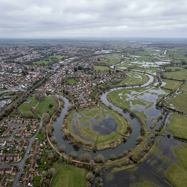
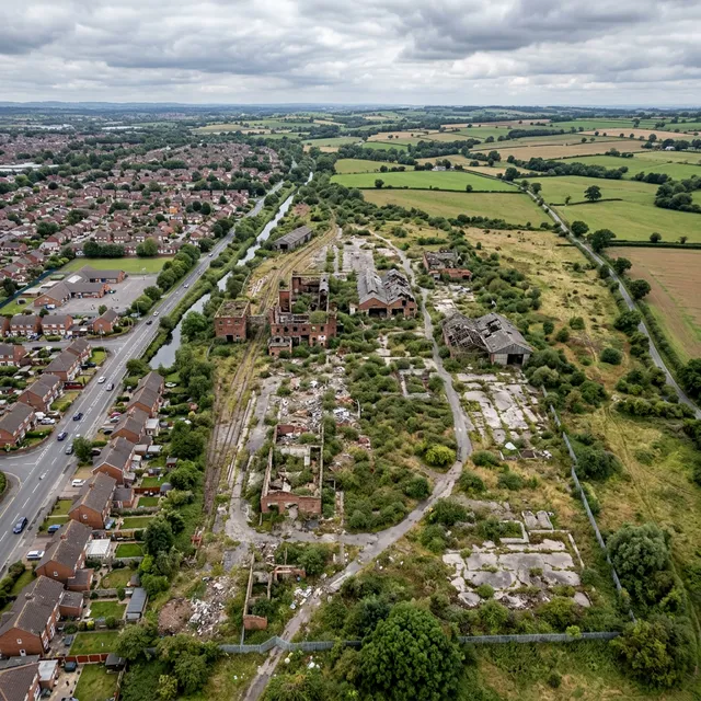
Grey belt land typically falls into two broad categories. The first is previously developed land sitting within the Green Belt — former industrial sites, disused farmyards, ex-military land, redundant commercial nurseries, derelict petrol stations, and similar brownfield sites that happen to fall within the Green Belt boundary. These sites are often surrounded by hardstanding, structures, or degraded ground, and they contribute very little to the openness or character of the countryside. The second category is open land that, when assessed against the five purposes, does not make a meaningful contribution to any of them. This might include land enclosed on three sides by existing development, land sitting between built-up areas without providing meaningful separation, or land that has been so degraded by fly-tipping, informal parking, or neglect that it no longer has the character of countryside.
Green Belt Reviews and Local Plan Allocations
Local planning authorities across England are now required to review their Green Belt boundaries as part of the plan-making process. The government has made clear that councils must consider releasing grey belt land before looking at higher-performing Green Belt. Many authorities — particularly in the South East, West Midlands, and Greater Manchester — have already commissioned or are commissioning Green Belt Reviews that assess every parcel of Green Belt land against the five purposes. These reviews typically produce a score or rating for each parcel, and those scoring weakly against all five purposes become prime candidates for grey belt reclassification and potential allocation for development.
The Golden Rules: 50% Affordable Housing and Other Conditions
The NPPF attaches specific conditions to grey belt development, sometimes referred to as the "golden rules." Paragraph 155 requires that development on grey belt land should provide a contribution to affordable housing of at least 50 per cent, unless the applicant can demonstrate through a viability assessment that this level is not achievable. Development must also provide necessary improvements to local or national infrastructure, and it must be consistent with the requirements for well-designed places set out in chapter 12 of the Framework. These conditions are significantly more demanding than typical planning requirements — a 50 per cent affordable housing target is above most Local Plan policies — and they need to be factored into any viability appraisal from the outset. Getting your numbers right before you submit is not optional; it is a condition of benefiting from the policy.
The draft London Plan, published for consultation in 2026, takes the grey belt concept further within the Greater London context. London contains approximately 35,000 hectares of Green Belt and Metropolitan Open Land. The draft Plan proposes a structured approach to identifying grey belt sites through the Spatial Development Strategy, with borough-level Green Belt Reviews feeding into the overall assessment. For developers and landowners operating in London's outer boroughs — Havering, Bromley, Hillingdon, Enfield, Barnet — this is a material shift. Sites that have been effectively frozen for decades may become developable within the next Local Plan cycle. The same logic applies to authorities in the wider South East, where Green Belt covers large areas of Surrey, Hertfordshire, Essex, and Kent.
The Opportunity for Landowners and Developers
For landowners, the grey belt policy creates a realistic pathway to development that did not exist two years ago. But it is not automatic, and it is not a free pass. Your land still needs to be assessed against the five purposes, and that assessment needs to be robust enough to withstand scrutiny from the local planning authority and, potentially, a planning inspector at appeal. A speculative planning application on Green Belt land without proper evidence of grey belt status is likely to be refused — and under the new expedited appeal rules taking effect in April 2026, you will not be able to introduce new evidence at appeal to rescue a weak application.
For developers, the opportunity is in identifying grey belt sites before the market fully prices in the policy change. Right now, many landowners with scrappy or underused Green Belt land do not yet understand that their site may have development potential. Land values in the Green Belt have historically been agricultural — £10,000 to £25,000 per acre in most of southern England. Residential development land in the same areas trades at £500,000 to £2,000,000 per acre or more. The gap between agricultural value and development value on a newly identified grey belt site is where the opportunity sits. But you need to move quickly: once a site is formally allocated through a Local Plan review, competition intensifies and prices adjust.
How to Assess Whether Your Site Qualifies
What should you do now? The first step is understanding whether your land is likely to qualify as grey belt. This requires a site-specific assessment that evaluates the land against each of the five Green Belt purposes, reviews the local authority's emerging or adopted Green Belt Review, checks for overlapping designations that might complicate development — such as AONB, SSSI, flood zone, conservation area, or heritage constraints — and models the viability implications of the 50 per cent affordable housing golden rule. Without this groundwork, you are guessing. A quick first check: our free Grey Belt & Land Opportunity Finder shows the council-level position for every English authority — delivery record, buffers, grey belt rating, and the affordable-housing percentage the Golden Rules would require.
Our Site Feasibility Report is designed to do exactly this. It screens your site against 27 constraint categories using 130 authoritative datasets, including Green Belt boundary data, NPPF grey belt criteria, emerging Local Plan allocations, and the full range of environmental, heritage, and infrastructure constraints. You receive a clear assessment of whether your site falls within the grey belt, what other designations apply, what the realistic development potential looks like, and what the likely planning friction points are — delivered within 48 hours.
Related Report
Feasibility Intelligence
Planning-ready intelligence from From £995 — delivered within 48hrs
Ready to get started?
Complete desktop planning intelligence for any site in England. From £295.